Over the mountains

Three mountain passes. One of them without convoy.

Vegferd sees the mountain passes on the route, the weather on the road surface where you pass, and whether you should pick another one. The example is Bergen–Geilo, 235 km over Hardangervidda; the same goes for Saltfjellet, Dovrefjell and Kvænangsfjellet.

3mountain passes to choose from235 kmover HardangerviddaBelow 0 °Con the road surface when you pass
Start
0 km
0 km · Before you leave

Three routes. Two of them have convoy driving.

Three routes to Geilo, and Vegferd compares them on the conditions where you pass: Hardangervidda good, Hol–Aurland and Hemsedalsfjellet poor with convoy driving. The fastest is 28 min faster than the next.

Route choice Bergen–Geilo: three routes, the fastest 4 h 7 min and 235 km over Hardangervidda, arrival 16:57, 28 min faster than the next route.
Shown on iPhone 17 Pro.
Compare three routes to Geilo on driving conditions: Hardangervidda good, Hol–Aurland and Hemsedalsfjellet poor with convoy driving.
Shown on iPhone 17 Pro.
4 km
4 km · Charging

Charge where it is free now.

The charging stations in order along the route, filtered on power and connector, and how many points are free right now: Circle K Nesttun, 400 kW, 4 of 6 free.

Charging along the route with filters for power, connector and operator: Circle K Nesttun 400 kW, 12 of 16, 3.9 km; Møller Bil Nesttun 150 kW; Recharge St1 Lone 5 of 5.
Shown on iPhone 17 Pro.
The charging station Circle K Nesttun: 400 kW CCS, 4 of 6 free, with the status of each charging point and when it was last seen.
Shown on iPhone 17 Pro.
25 km
25 km · On the way

See the road before you are there.

The road camera at Trengereid on the E16, towards Bergen and towards Voss, with the picture from right now. And the rest areas along the route, with what they have.

Road camera Trengereid on the E16, towards Bergen and towards Voss, both pictures from 12:54, right now.
Shown on iPhone 17 Pro.
The rest areas along the route in order, from Trengereid to Tyrvefjøra, with toilets and charging where they exist, and “Add” on each.
Shown on iPhone 17 Pro.
169 km
169 km · On the mountain

The weather where you pass, not where you started.

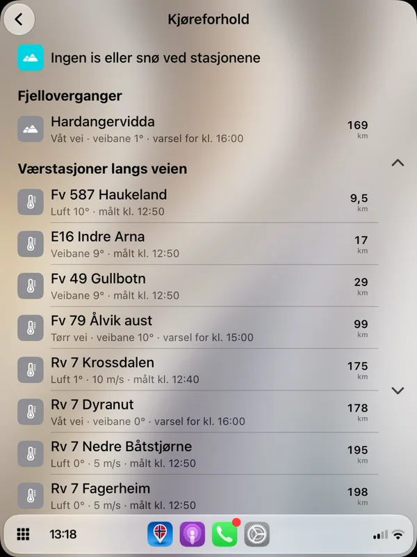
The driving conditions as a graph: the road surface temperature drops below zero over Hardangervidda, with the weather and road warnings for the hour you are there. On the car screen too.

Driving conditions to Geilo, 235 km: the weather forecast along the route and the graph where the road surface temperature drops below 0 °C over Hardangervidda.
Shown on iPhone 17 Pro.
Vegferd in Apple CarPlay on a tall car screen: the driving conditions along the route with Hardangervidda and the weather stations.
235 km
235 km · Electric car

The energy follows the hills.

Least energy over Hardangervidda, +19 % over Hol–Aurland and +48 % over Hemsedalsfjellet. The climb is counted in, so you know before you choose.

Compare electric car: least energy over Hardangervidda, +19 % over Hol–Aurland and +48 % over Hemsedalsfjellet, with the climb 3283, 3507 and 4000 metres.
Shown on iPhone 17 Pro.
The essentials of the fastest route to Geilo: 4 h 7 min, 235 km, 28 min faster than the next route, 2 toll stations for 92 kr, the mountain pass Hardangervidda.
Shown on iPhone 17 Pro.
Arrival

Over the mountains with Vegferd.

Free to use. The driving conditions along the route, the weather stations and the route over another pass are Pluss.