Through the city

The fastest way into and through the city. Right now.

In the city, the traffic decides. Vegferd uses the speed the Norwegian Public Roads Administration measures right now, the messages ahead of you and the toll stations with prices. The example is Bergen; the same goes for the approach roads into Oslo, Trondheim and Stavanger.

4½ minmeasured Kristianborg–Danmarksplass+1 minin the Arnanipa tunnel when you pass3toll stations, 53 kr
Start
0 km
0 km · Before you leave

Will there be queues?

Vegferd knows how the traffic usually is, hour by hour, where the roads administration measures, and answers for your trip: calm all the way, or queues where you pass, and whether a break would help.

Traffic flow: will there be queues? No, calm all the way. The cities you pass are calm then. And: what if you take a break? A break changes little.
Shown on iPhone 17 Pro.
Traffic flow in Bergen when you pass, about 13:03–13:15: calm when you pass, 11 min now against 9½ min when it is calm, Haukeland–Arnanipa tunnel +1 min.
Shown on iPhone 17 Pro.
3 km
3 km · Measured speed

4½ min. As usual.

On the approach roads into Oslo, Bergen, Trondheim and Stavanger the roads administration measures the speed now. Kristianborg–Danmarksplass: 4½ min, against 4 min in free flow, measured at 15:45. The colour of the road shows the traffic where it is.

Measured speed on the map of Bergen: 49 km/h, average speed over 3.6 km, Kristianborg–Danmarksplass 4½ min, as usual, with the traffic flow coloured on the roads.
Shown on iPhone 17 Pro.
Measured speed Kristianborg–Danmarksplass, the full card: 4½ min now, 4½ min usually, 4 min in free flow, with the graph for today against a usual Saturday.
Shown on iPhone 17 Pro.
6 km
6 km · The messages

The message before you are there.

Roadworks, traffic lights and reduced speed limits from the roads administration, in the order you meet them and with the status when you pass. The warning comes on the screen and by voice about 2 km before.

The traffic messages along the route with status when passing: Haukanes 112 km passing 17:00, roadworks and traffic lights; Tuve 343 km; Nypefoss bridge 420 km, reduced speed limit.
Shown on iPhone 17 Pro.
The traffic messages in order with kilometres and times: Knappahola roadworks, periodically closed; E134 Seljestad–Håra emergency services, road open; Vetlehovden manual traffic control.
Shown on iPhone 17 Pro.
9 km
9 km · The toll

The price before you pass.

The toll stations in order with the price for your vehicle, under one total. If you pass the same station out and back, it is listed twice. If the price is unknown, it says so, instead of a guess.

Costs: 323 kr in total, 3 toll stations and 2 ferries. E39 Endalausmarka 36 kr, Halhjem–Sandvikvåg 123 kr, Mortavika–Arsvågen 147 kr, E39 Tastatorget 17 kr, E39 Mosvatnet included in the hourly rule.
Shown on iPhone 17 Pro.
12 km
12 km · Arrival

The sign, the speed and the lane.

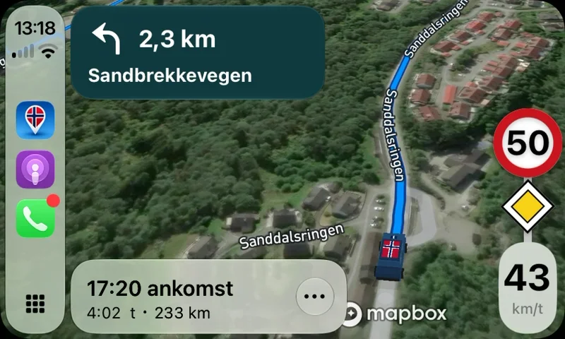
The speed limit and the priority road on the sign post, your speed below it, and the road number as it stands along the road. The elevation profile at the bottom follows you the whole trip.

Navigation on an iPhone: turn left in 3.0 km onto Sandbrekkevegen, the sign post with speed limit 50, priority road and speed 43 km/h, arrival 16:57, and the elevation profile at the bottom.
Shown on iPhone 17 Pro.
Vegferd in Apple CarPlay: the next turn, speed limit 50, priority road and your speed, the same sign as on the phone.
Shown on the car screen.
Arrival

Through the city with Vegferd.

The traffic, the messages and the toll stations are free. Queue warnings on the way and speed cameras are Pluss.